LiDAR360: process every point cloud you capture
GreenValley's point cloud platform for drone, terrestrial and mobile LiDAR. More than 260 tools, AI classification and modules for terrain, forestry, mining, buildings, imagery and spectral data. Buy the Full Suite, or the Framework plus only the modules you need.
- AI point cloud classification
- Model Builder workflows and batch processing
- Python API and a built-in AI assistant
- Drone LiDAR QC and accuracy reports
LiDAR360 prices
Every module runs on the Framework. The Full Suite includes the Framework and all eight modules, for $4,501 less than buying them one by one.
GreenValley list prices. Licenses are delivered by email as a license key; nothing ships.
Perpetual licenses: free updates within a version (for example 9.x to 9.y) and free major upgrades for 12 months after activation. After that a major upgrade is 20% of the new version's list price.
Annual licenses run 12 months.
What each LiDAR360 module does
Ground, DEMs, contours and volumes
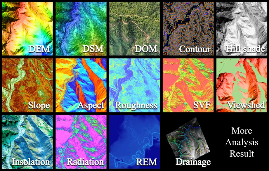
Ground classification, 15 terrain products, volume measurement, change detection, sections and hydrology: REM, drainage and flood areas.
Open-pit and tunnel work
Earthwork and volume change, crests and toes, inter-ramp compliance, section analysis and tunnel deformation monitoring.
Tree-by-tree inventory
Individual tree segmentation, 100+ species recognition and 28+ attributes such as height, crown, trunk volume and biomass.
City-scale building models
Separates buildings from terrain and vegetation and models them for digital twins.
Orthophotos from your flight
RGB, infrared and multispectral orthophotos, with automatic target detection and GCP matching.
Spectral and LiDAR together
Denoise, enhance and classify spectral data and fuse it with the point cloud: spectral profiles, spectral angle classification, NDVI.
Stockpiles, topo and earthwork from one point cloud
The Terrain module carries a site from raw points to deliverables: classify the ground, build the DEM and contours, measure volumes, and compare two surveys to see what moved.
- Ground classification
- DEM, DSM and contours
- Volume measurement and change detection
- Section analysis
AI classification, workflows and an assistant that runs the software
Classify ground, vegetation, buildings, power lines and more with built-in AI models, or train your own. Chain more than 200 tools into one-click workflows with Model Builder, and let the AI assistant set parameters and fix errors for you.
- AI point cloud classification
- Model Builder and batch processing
- Python API
- Trajectory adjustment, registration and coordinate projections
LiPowerline and LiGeoreference
LiPowerline analyzes power line corridors: AI classification of conductors, towers and vegetation, hazard and clearance analysis, and inspection route planning. LiGeoreference processes LiAir drone data.
GreenValley list prices. Licenses are delivered by email as a license key; nothing ships.
Questions we get
Perpetual or annual?
A perpetual license is yours to keep, with free updates within the version and free major upgrades for 12 months. An annual license costs less up front and runs for 12 months. Most survey firms buy perpetual.
Do I need the Framework?
Yes. Every LiDAR360 module runs on the Framework, so buy the Framework plus your modules, or the Full Suite, which includes both.
Which modules do I need for stockpiles and topo?
The Framework and the Terrain module cover ground classification, DEMs, contours and volumes. Add the Mine module for open-pit work.
What is the difference between LiDAR360 and LiDAR360 MLS?
LiDAR360 is built for drone and terrestrial data: terrain, forestry, mining and imagery. LiDAR360 MLS is built for handheld, backpack and vehicle scanners such as the LiGrip: floor plans, BIM, trenches, roads and Gaussian Splatting.
Not sure which LiDAR360 modules you need?
Tell us what you capture and what you deliver, and we will tell you straight which license fits.